
Land Surveying
Geomatics

This project was conducted solely for experimental purposes to create an approximate shape file of the park boundary (perimeter), not for any legal purposes, nor should one intend to follow such methodology or workflow for legal purposes. All outsourced data utilized was open-source data referenced throughout the project, including templates, geospatial data, standards, etc.
What is land surveying?
Land surveying is the science of measuring positions, distances, and angles on or near Earth’s surface. It forms the foundation of property delineation, engineering layouts, and geospatial science. In a legal context, land surveys are conducted using certified equipment and registered under provincial or federal survey standards. However, academic and environmental surveying can also involve non-legal tools and GIS workflows to build spatial awareness, analyze environmental degradation, and support conservation planning.
1. Theodolite
A theodolite is a precision optical instrument used in traditional land surveying. It measures horizontal and vertical angles between points, often mounted on a tripod. Theodolites are especially useful for creating accurate triangulations, calculating elevations, and aligning property boundaries. They are typically used by licensed surveyors in legal and engineering-grade work.
2. Survey-Grade GNSS Receiver
This is a high-precision GPS system used by professional land surveyors. It uses satellite signals (from systems like GPS, GLONASS, Galileo) along with differential correction methods such as Real-Time Kinematic (RTK) or Post-Processed Kinematic (PPK). These receivers can determine a point’s position with centimetre-level accuracy, which is required for legal boundary surveys, construction layouts, and cadastral mapping.
3. Handheld GNSS Device (Non-Legal Use)
A handheld GPS (like the NOYAFA NF-198) is a portable GNSS receiver that captures location data with 1 to 5 meter accuracy. It’s useful for preliminary mapping, environmental studies, and educational fieldwork. While it can show a general location with a maximum of 1 m + accuracy, connected to 10+ satellites, it is not precise enough for legal property surveys or engineering design and should only be used for non-legal applications such as research, planning, or recreation.


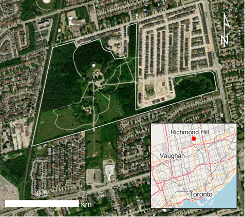
A GPS Survey of the DDO Lands

Kyle Edward Kuthe, Maryann Anastasakos - Field Assistant
🕒 Estimated reading time: 12-15 minutes
This project investigates whether a boundary created using handheld GPS, anchored by ground control points and adjusted through a transformation matrix, offers greater spatial accuracy for GIS-based studies than one defined by visually tracing satellite or aerial imagery. While not survey-grade, the GPS data were corrected using three ground control points. The average difference in magnitude between measured and known GCPs was applied as a transformation to all points, producing a boundary more suitable for spatial analysis and georeferenced dataset integration than image-based approximations such as Google Earth digitization.
1. Plan a Methodology
The methodology combines modern GIS and traditional surveying workflows, while the visual appearance and criteria will be derived from templates roughly following the National standards for the survey of Canada Lands, although NOT the methodology for surveying, as that would require an extreme level of precision, requiring a high-end and expensive land surveying tool (and not what this study is about). On the other hand, the Canada Lands Survey Standard is what should be used when professionally surveying the DDO Park for the City of Richmond Hill. However, when we received the most uptodate city plans of the park (which we are unfortunately not able to share/reproduce), we received two. The latest (public) survey the city allowed access to for the study (with $80 fee) as of 2025, was taken in 2015, which was over ten years ago.
General Methodology:
-
Goal: To practice a process of land surveying; survey the DDO lands; create a boundary for GIS work (shapefile); get insights into the accuracy of this process.
-
Using archival data via online, find 3 of the closest Ground Control Points (GPS).
-
Field data collected using a handheld GPS (NOYAFA NF-198 GPS Land Meter).
-
Coordinates corrected via known GCP sourced from wherever is closest - Municipal.
-
Coordinate upload and cleaning using Python, Excel and ArcGIS Pro; transform GCP to the same projection to WGS.
-
Coordinate transformation using 2D translation in Python.
-
Final output: accurate shapefile and annotated parcel plan.
2. Get 3 Ground Control Points (GCP)
To improve the spatial accuracy of the GPS points and thus boundary, this project applied a basic 2D translational transformation by comparing measured GPS coordinates to known Ground Control Points (GCPs). This ensures the educational boundary is more aligned with real-world features for GIS analysis.
The most local to the boundary were 3 municipal points:


Each GCP was marked using the handheld GPS. The difference between measured and known coordinates was calculated and used to apply a consistent transformation to all other collected points.

3. Collect Field Data Points

Field data was collected on foot across the DDO property on September 22, 2024:
-
Approximately 50 points were collected along the perimeter including the GPS coordinates at the GCP.
-
Each point is logged with time, coordinates, satellite count (11 always) automatically in the GPS, and was also manually in the fieldbook.
-
Natural and artificial features (fences, past monuments/markers, paths, tree lines) were used to inform boundary logic while staying on public property. Reference to historical maps and surveys were also informed for best places to take our recordings.


4. Process & Prepare Data Points
To improve the spatial accuracy of the GPS boundary, this project applied a basic 2D translational transformation by comparing measured GPS coordinates to known Ground Control Points (GCPs). This ensures the educational boundary is more aligned with real-world features for GIS analysis.
B. Transform data to WSG NAD
-
A. Upload raw GPS points data to spreadsheet, ensuring they align to fieldnotes
-
Raw GPS points were compiled in Excel and processed in Python using GeoPandas and pyproj
-
Coordinates transformed into MTM NAD27 Zone 10 system (per Ontario legal surveying standards)
-
Applied a 2D translational matrix using the average offset between measured and known GCP coordinates
-
Errors were logged and final spatial tolerance was ±15.74 metres
5. Create A Shapefile (.shp)
Points were joined to form a closed polygon boundary of the park
The shapefile was created using ArcGIS Pro and exported for use in NDVI overlays and cartographic analysis
Topology was cleaned and metadata added (coordinate system, projection, method notes)


6. Create a Final Plan for the Parcel
Using ArcGIS and AutoCAD, a final parcel plan was created
Includes:
Bearings, azimuths, and distances
North arrow and legend
Georeferenced overlays from historical municipal survey plans
Notes on forest loss, trail expansion, and hydrology changes
Key Insights
This survey demonstrated that even consumer-grade GPS, when paired with basic geodetic corrections, can produce valuable spatial data for environmental research. It enabled:
-
Accurate base mapping of DDO forest degradation
-
GIS-ready shapefiles for NDVI and remote sensing
-
Overlays with historic legal plans to track land transformation
-
A method for other conservation groups to replicate at non-legal scales